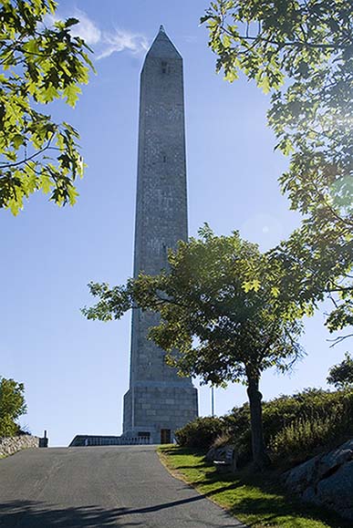
Soldier's Memorial at High Point, NJ
The highpoint of New Jersey is in the High Point State Park in the far North-West corner of the state, just a few miles from Port Jervis, NY. It's an easy drive from New York City, but it's just far enough out that as you get within 30 miles or so of the park, the slums have given way to suburbs and the suburbs have given way to rolling hills with pretty fields, farms and forests.
I arrived at the end of September and the road was lined with farmer's stands selling pumpkins and chrysanthemums; the weather was a perfect warm autumnal afternoon and the view from New Jersey's highest point was lovely. Hawks soared in the sky over the valley and the leaves were just showing a hint of color.
The park entrance is on the right of Rt 23 North, and a paved road leads from the entrance all the way up to the 200-foot mini-Washington Monument with parking at the foot. The monument was erected in 1930 to memorialize all the Americans who had fallen in the service of their country; barely a decade before our worst foreign war.
|
|
|
Soldier's Memorial at High Point, NJ |
Directions to High Point, NJ from the the NYC area (east/south)
From the South: Take I-287 to Rt 23 North
From the GW Bridge: Take I-80 West to Rt 23
North
Follow Rt 23 North to High Point State Park
~ 7 miles north of Sussex, NJ
~ 3 miles north of Colesville, NJ
The road goes directly up to the monument at the summit with parking just below
Maine's highest mountain, Katahdin, is the centerpiece of Baxter State Park. Comprised of 204,733 acres and located some 300 miles north of Boston, Baxter is unusual if not unique among parks. In much the same way that Grand Teton National Park was assembled and donated by the Rockefeller family in the 1920s, Baxter was assembled by Percival Baxter following his retirement as Maine's Governor in 1925.
What is unusual about Baxter State Park is that its donor stipulated that the wilderness aspect of the park should supersede its recreational aspect and to a large extent this has been honored. The result is a lovely, undeveloped ruggedness and somewhat stringent regulations that some people find restrictive. An example is the process by which campsite reservations are taken. Until recently, you had to show up in person on January 17th to hand in your campsite reservation request at the park headquarters. The system has been relaxed somewhat and a rolling four-month mail-in reservation system is now in place for a majority of the campsites but the town of Millinocket is still the scene, in the dead of the bitter Maine winter, of people camping out in order to secure their place in line.
I stayed outside the park in a motel in Millinocket (sort of Baxter's Jackson's Hole), one of several situated along the main (and pretty-much only) road in town, namely Rt 11/157, called Central Street. Inexpensive, clean and friendly, it was more than adequate with free continental breakfast beginning at 5AM and free wireless Internet access.
Maine is the scene of an environmental and economic tug-of-war between the local residents and the Nature Conservancy. The economy of central Maine is dominated by the paper business and its subsidiary business, lumbering. The next-most important business is that of tourism which includes hunting, fishing, hiking, camping and photography. The paper business has been having a difficult time for years and as a result the local population depends ever more on tourism; and this tourism depends on access to the vast woods that for the most part are privately owned by the paper and lumber companies.
In the early days of the lumber industry, loggers would work all winter cutting timber and dragging it to the frozen lakes where they piled it up on the ice. Come Spring, the ice would melt and the logs would be floated down the streams and rivers to the mills. In the 1960s environmental awareness grew in the United States, with dramatically beneficial results for the most part; one of the new environmental laws prohibited the floating of logs on rivers. In response, the paper and logging companies developed a network of private roads to support the huge logging trucks that they now needed to carry the timber.
In the Millinocket area, the Great Northern Paper company provided the economic life blood for the community, and it fell on hard times. The company changed hands several times, becoming a smaller employer with each name change. At one point it was being bled by its then-owners who mortgaged vast tracts of their land; the Nature Conservancy held the paper on quite a bit of this when the company once more went into bankruptcy. As a result, the Nature Conservancy is now a very large Maine land owner.
However, the Nature Conservancy's objectives do not coincide with those of the locals ... whereas the timber and paper companies were happy to have hunting guides and others use their roads, the Nature Conservancy is not and it has torn the roads up and piled huge boulders on them to prevent anyone from using the roads to access the wilderness. While there is an admirable objective underlying this, the effect on the local outdoorsmen has been hard.
Another factor is also now at work, namely developers. In a spirit completely opposite that of the Nature Conservancy, some other land has been acquired with hotels, houses and golf courses in mind. It remains to be seen how all this will play out. Perhaps in the end a balance will be struck that will help support the local economy and also preserve large tracts of wilderness for the benefit of the environment and future generations of nature lovers. We can only hope.
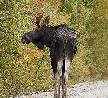
During the second week of October the leaves are brilliant and the bull moose are in rut with their dramatic antlers in full display (if you can find them; serendipity may play a role but otherwise it's helpful to have a guide to take you to the wild parts outside the park; I can recommend Dale Stevens). Bald Eagles nest here, too, and black bear are plentiful, if shy. In 2005 the weather wasn't the best for my climb but it was still a great time to be outdoors in and above the Maine woods.
The "tote road" inside the park forks immediately after the Togue Pond entrance gate and you can climb from campsites on either side of the mountain. I chose the left fork and parked at the Katahdin Stream Campground. The last stage of the Appalachian Trail runs through the campground and its northern terminus is at Baxter Peak, the highest point of Katahdin. The park gate opened at 6:00AM and I was there waiting at 5:45AM, behind several other vehicles.
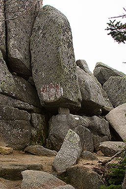
The climb has basically three stages. The first and third are relatively easy hikes through the woods and over rocks; the middle third is quite difficult, requiring hard scrambling over a vast pile-up of boulders that measure 10 to 15 feet on a side.
You start out in the pine woods, following and sometimes walking in the Katahdin stream. There's a pretty waterfall and the path is fragrant and lovely with pines, birches, maples, sumac and ash. The path mostly runs in deep woods but from time to time you emerge to a view of the vast woods spread below you, all green, yellow and red with ponds glistening like scattered silver. Hiking poles are handy and you will pant and work up a sweat, but the lower third of the climb is nothing any active person couldn't easily accomplish.
The trail is 5.6 miles long and at some point you come to a rock that is marked with "3 M" and an arrow pointing to the summit. You think to yourself, "Half-way done! That wasn't so bad.". By the time you come to another rock marked "2 M", however, you will have gotten a very different perspective on things. Almost immediately after the "3 M" sign, you come out of the trees and are faced with a very steep grade stretching up into the sky consisting entirely of enormous boulders you have to climb around and over. From time to time you come to iron bars hammered into the rock to help you haul yourself up, but for the most part it's hands and feet and knees and elbows. This part of the trail demands excellent hiking boots to provide support and secure footing, and the hiking poles become more of a hindrance than a help.
The "2 M" mark is not the end of your ordeal, you have another 1/2 mile or so to go until you climb out onto the plateau of Thoreau Spring. Here, you are completely above the tree line and the only vegetation is very low mosses, lichen and grasses. Signs implore you to stay on the trail because of the delicacy of these sub-alpine plants.
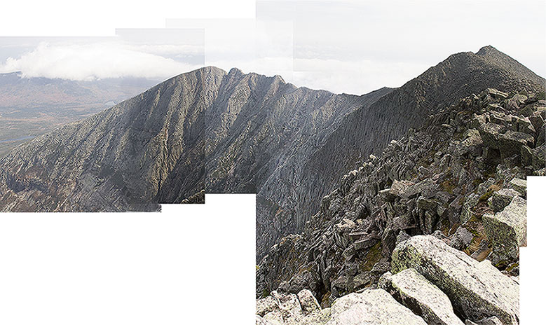
The climbing from here to Baxter Peak is not easy but it is considerably more so than what you've accomplished. The view from the summit is quite spectacular, if the weather will permit. Looking down the opposite face from the one you've just climbed, you see a sheer rocky precipice with streams and lakes far below and in the distance (see my photo below). To the right, extending into the near horizon, is the Knife's Edge leading to further peaks of Katahdin.
The peak is 5,267 feet above sea level, 4,168 vertical feet above your starting point at the campsite. Reaching the summit is a great achievement but as with all mountains the descent is riskier because you're tired and climbing down backwards is in many ways more difficult than climbing up as you lurch awkwardly head-first toward the abyss. Take good care.
|
|
|
Terrible attempt at a panoramic image from Baxter
Peak at the summit of Katahdin |
|
|
|
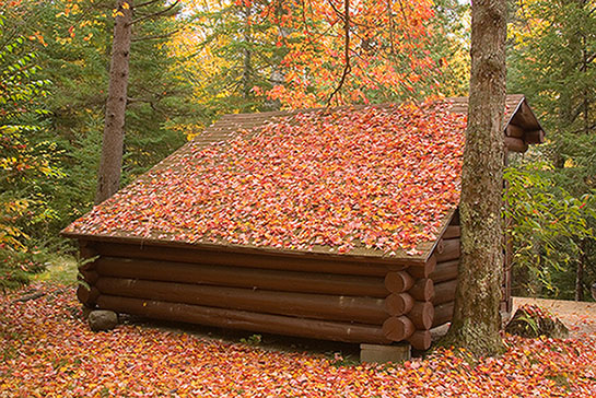
A lean-to at the Katahdin Stream Campground, in Autumn |
|
|
|
|
Young Bull Moose |
Katahdin Boulders |
Take I-95 to Exit 244, Rt. 11/157, to Millinocket, ME
Drive through East Millinocket (with the
large paper mill to your left along the river) and then Millinocket
The Baxter State Park headquarters is on the left as you drive through town;
you should stop in.
At the far end of Millinocket take a right and then a left (clearly marked with brown Baxter State Park signs) and follow the road to the Togue Pond Gate where you register. Bear left after the gate (the rangers will direct you).
The Appalachian Trail route (called the Hunt Trail by the Park) begins at the Katahdin Stream Campground which has plenty of daily parking if you get there early. Camping in the park requires lots of advance planning; staying in a local motel or cabin is easy and inexpensive.
It's 339 miles from Boston to the Katahdin
Stream Campground.
An expensive alternative is to fly into Bangor or Bar Harbor and rent a car.
Millinocket also has a private airport.

For George Fisher's main Highpoint page, click here
© Copyright George Fisher 2005 all rights reserved
| Please note that hiking and mountain climbing are
dangerous sports and many people are injured or killed every year
participating in these activities. The author is not responsible for
any misadventures resulting from the information provided on this
site. Anyone participating in these sports does so entirely at their own risk. |